الوضع الليلي


 1:38:42
  2025-07-26
  2011
2011
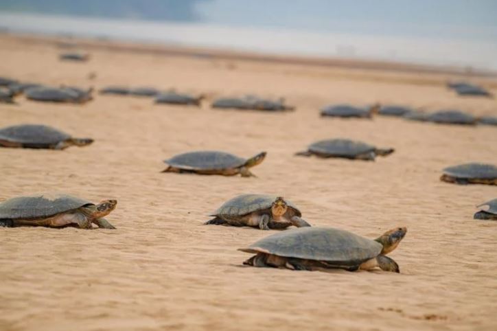
Researchers from the University of Florida have created a more precise method for counting wildlife using drones. This advancement played a key role in verifying the largest known nesting site for a threatened turtle species anywhere in the world.
The team combined drone-captured aerial images with advanced statistical modeling to identify and count over 41,000 Giant South American River Turtles along the Guaporé River in the Amazon. Their results, published in the Journal of Applied Ecology, provide conservationists with a valuable new approach for monitoring at-risk animal populations more accurately.
“We describe a novel way to more efficiently monitor animal populations,” said lead study author Ismael Brack, a post-doctoral researcher within the UF Institute of Food and Agricultural Sciences’ (UF/IFAS) School of Forest, Fisheries and Geomatics Sciences. “And although the method is used to count turtles, it could also be applied to other species.”
From Conference to Collaboration
The project began with Wildlife Conservation Society (WCS) researchers in Brazil, Colombia, and Bolivia. One of the species the New York-based organization monitors is the Giant South American River Turtle, which is threatened by poachers who sell its meat and eggs. The turtles are exceptionally social creatures, and females congregate each year in July or August to nest in the Guaporé River sandbanks between Brazil and Bolivia.
Brack met WCS scientists at a conference, and they shared how they use drones to count the turtles, he said. They create orthomosaics, which are highly detailed, high-resolution composite images made by stitching together hundreds of overlapping aerial photographs.
Counting the animals shown in orthomosaics is a quicker, more accurate, and less invasive approach than counting animals from the ground. The method alone, however, doesn’t account for the fact that animals sometimes move during observation.
Together, researchers from UF and the WCS developed a method that improves counting accuracy by eliminating multiple sources of error, including double counts (the same individual counted multiple times) and missed individuals.
Researchers used white paint to mark the shells of 1,187 turtles gathering on an island sandbank within the Guaporé River, according to the study. Over 12 days, a drone flew overhead on a meticulous, back-and-forth path four times a day and snapped 1,500 photos each time. Using software, scientists stitched the photos together, and researchers reviewed the composite images.
They recorded each turtle, if its shell was marked and whether the animal was nesting or walking when photographed. Equipped with this data, they developed probability models that account for individuals entering and leaving the area, observed turtle behaviors, and the likelihood of detecting an identifiable shell mark.
Errors Revealed in Traditional Methods
The models revealed several potential sources of error that could arise from traditional orthomosaic-based counts, according to the study. Only 35% of the turtles that used the sandbank, for example, were present during drone flights. And, on average, 20% of the those detected walking appeared multiple times in orthomosaics — some as many as seven times.
Observers on the ground counted about 16,000 turtles, according to the study. Researchers who reviewed the orthomosaics but didn’t account for animal movement or shell markings counted about 79,000 turtles. When they applied their models, however, they estimated about 41,000 turtles.
“These numbers vary greatly, and that’s a problem for conservationists,” Brack said. “If scientists are unable to establish an accurate count of individuals of a species, how will they know if the population is in decline or whether efforts to protect it are successful?”
The study describes ways to adapt and apply the approach to conservation efforts involving other species surveyed by drone-derived orthomosaics. Past monitoring studies, for example, have involved clipping seals’ fur, attaching high-visibility collars to elk, and marking mountain goats with paintball pellets to keep track of animal movement during counts.
The research team plans to perfect monitoring methods by conducting additional drone flights at the Guaporé River nesting site and in other South American countries where the Giant South American River Turtle gathers, including in Colombia and possibly Peru and Venezuela, Brack said.
“By combining information from multiple surveys, we can detect population trends, and the Wildlife Conservation Society will know where to invest in conservation actions,” he said.
Reality Of Islam |
|

A new gener

Building a

Now in spac

NASA’
 9:3:43
2018-11-05
9:3:43
2018-11-05
10 benefits of Marriage in Islam
7:5:22
2019-04-08
benefits of reciting surat yunus, hud &
9:45:7
2018-12-24
advantages & disadvantages of divorce
11:35:12
2018-06-10
6:0:51
2018-10-16
7:0:55
2022-05-17
2:33:4
2023-02-15
1:38:41
2021-12-08
7:32:24
2022-02-14
6:14:3
2023-01-18
11:34:48
2022-06-29
9:42:16
2022-10-19
5:41:46
2023-03-18
| LATEST |
 HOME
HOME